Technology
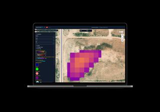
Scepter offers an unparalleled approach to atmospheric intelligence by integrating multi-platform, multi-sensor data across scales into one centralized, comprehensive high-resolution visualization of atmospheric pollutants - climate gasses and criteria pollutants - in the dynamic vertical air column.
ScepterAir
The ScepterAir data fusion engine rapidly ingests, processes, and analyzes anomaly-relevant atmospheric and Earth-observation inputs. By combining satellite images, airborne surveys, stratospheric balloon imagery, drone/UAV monitoring, and terrestrial sensor data—along with meteorological and geospatial contextual data—ScepterAir generates high-resolution anomaly maps and alerts in minutes or hours, not days. It is architected on Amazon Web Services to ensure scalability, flexibility, and security.
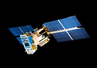
Satellite Constellation
While ScepterAir already ingests geostationary and low Earth orbit (LEO) satellite data, Scepter is deploying its own high-resolution LEO constellation optimized for anomaly detection: simultaneously monitoring climate gases, mineral signatures, and hazardous releases. This constellation enhances temporal and spatial detection capabilities—providing near real-time detection and precise tracking of methane, rare-earth extraction sites, clandestine tunnels, and CBRN events.
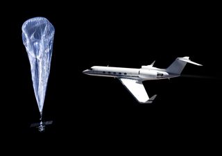
Aircraft and High-Altitude Platforms
Aircraft-based surveys carrying specialized sensors to overfly, map, and track anomalies, providing targeted, localized anomaly detection. In conjunction with Aircraft, Scepter's capabilities can deploy stratospheric balloons/High-Altitude Pseudo-Satellites (HAPs) to monitor regions continuously and with high repeat frequency—ideal for detecting methane plume evolution, mineral dust transport, or underground disturbances.
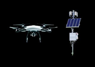
Third-Party Drones, UAVs, and Terrestrial Sensors
As a key part of the anomaly detection ecosystem, ScepterAir ingests data from customer-provided and public UAV/drones and ground sensor networks. This includes local methane sensors, ground-penetrating radar data, geological surveys, and IoT networks. The fusion of these data sources enables high-confidence anomaly detection, classification, and source attribution—even when anomalies originate underground, underwater, or in dense infrastructure zones.